
มรดกธรรมชาติ
แห่งลุ่มน้ำโขง
Natural Heritage
of the Mekong
ผืนแผ่นดินหินทรายอันกว้างใหญ่ไพศาล ร่องรอยซากดึกดำบรรพ์ยุคครีเทเชียส และศิลปะก่อนประวัติศาสตร์ที่หาดูได้ยากยิ่งในภูมิภาคอาเซียน Vast sandstone plateaus, Cretaceous paleontological traces, and prehistoric rock art — among the most remarkable geological heritage in Southeast Asia.


คุณค่าระดับโลก
3 ด้านหลัก
Three Pillars of
World-Class Value
อุทยานธรณีอุบลราชธานีโดดเด่นด้วยคุณค่าทางธรณีวิทยาที่หาดูได้ยากยิ่งในระดับสากล ทั้งด้านบรรพชีวินวิทยา ธรณีสัณฐาน และกระบวนการผุพังอันหายาก Ubon Ratchathani Geopark stands out for its globally significant geological heritage across three exceptional scientific domains found nowhere else in Southeast Asia.
ขุดค้นพบฟอสซิลไดโนเสาร์และฟันปลาฉลามน้ำจืดโบราณ ณ แหล่งโบราณคดีโคกผาส่วม อายุสะสมช่วงปลายยุคครีเทเชียส (ราว 100–75 ล้านปี) เป็นชั้นหินไดโนเสาร์ที่อายุน้อยที่สุดในประเทศไทย Fossil discoveries at Khok Pha Suam spanning the late Cretaceous period (approx. 100–75 million years), representing Thailand's youngest dinosaur-bearing rock strata.
Cretaceous Paleontologyสามพันโบก — ปรากฏการณ์หลุมแอ่งกลมรูปถ้วยนับพัน เกิดจากน้ำวนกัดเซาะหินทรายมานานนับพันปีริมฝั่งโขง ถือเป็นแหล่งกุมภลักษณ์ที่ใหญ่ที่สุดและสวยงามที่สุดในเอเชียตะวันออกเฉียงใต้ Sam Phan Bok — thousands of bowl-shaped potholes carved by swirling Mekong currents over millennia, considered the grandest and most spectacular pothole field in Southeast Asia.
Mekong Pothole Geomorphologyรูพรุนกลมเล็กสม่ำเสมอนับหมื่นรูบนหน้าผาหินทรายเลียบโขง เกิดจากปฏิกิริยาการละลายทางเคมีและกายภาพที่หาพบได้ยากยิ่งในระดับโลก บ่งบอกกระบวนการผุพังธรรมชาติที่ยาวนานนับล้านปี Tens of thousands of regular micro-cavities on towering Mekong sandstone cliffs — a globally rare physical-chemical weathering process documenting millions of years of geological transformation.
Rare Porous Weathering
แหล่งธรณีใน
4 อำเภอหลัก
Geosites Across
4 Districts
อุทยานธรณีอุบลราชธานีประกอบด้วยแหล่งท่องเที่ยวทางธรณีวิทยาที่ขึ้นทะเบียนแล้ว 46 แห่ง กระจายตัวใน 4 อำเภอริมฝั่งแม่น้ำโขง 46 officially registered geosites spread across four districts along the Mekong River, each offering a distinct geological narrative.
แก่งหินสลักริมโขง คลังกุมภลักษณ์ขนาดใหญ่ และหาดทรายขาวสวยงาม Mekong rapids, vast pothole structures, and pristine riverside sand dunes.
-
สามพันโบกSam Phan Bokแอ่งกุมภลักษณ์พันหลุมPothole Field Wonder
-
ปากบ้องPak Bongร่องโขงแคบที่สุด (56 ม.)Narrowest Mekong Gorge (56 m)
-
หาดสลึง & หาดหงส์Hat Salung & Hat HongเนินทรายริมโขงMekong Riverside Dunes
-
ศิลาเลขSila Lekจารึกระดับน้ำโบราณAncient Water Level Inscriptions
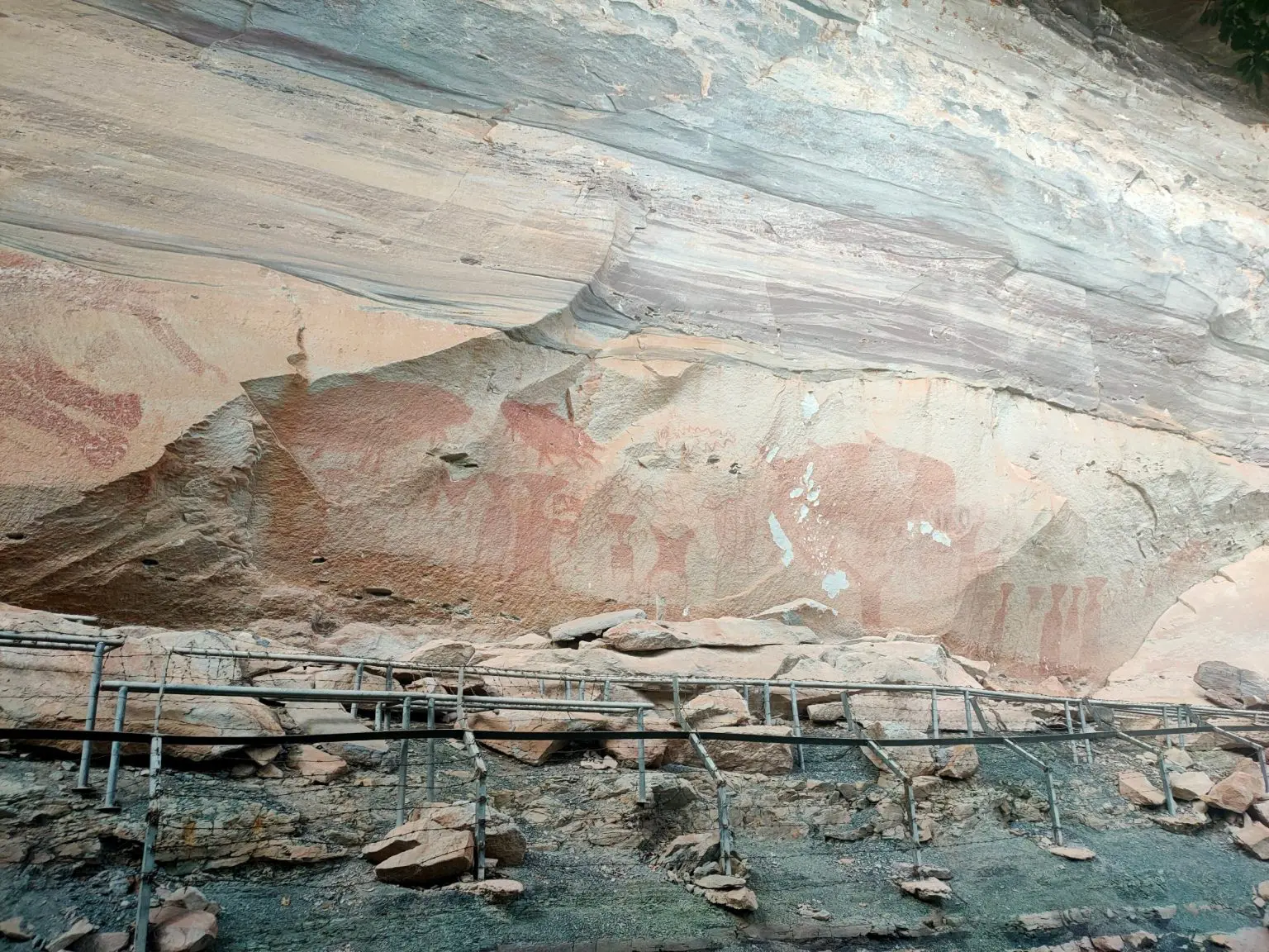
ชั้นหินทราย ภาพเขียนสีก่อนประวัติศาสตร์ หน้าผาชันและธารน้ำตกลานหิน Sandstone stratigraphy, 4,000-year prehistoric art, towering cliffs, and scenic waterfalls.
-
ผาแต้มPha Taemภาพเขียนสีก่อนประวัติศาสตร์ 4,000 ปี4,000-Year Prehistoric Rock Art
-
เสาเฉลียงคู่Twin Earth PillarsเสาหินทรายธรรมชาติTwin Natural Sandstone Columns
-
น้ำตกแสงจันทร์Moonlight Waterfallน้ำตกลอดรูหินหนึ่งเดียวFalls Through a Natural Rock Hole
เป็นแหล่งท่องเที่ยวสายธรรมชาติและธรรมะ โดดเด่นด้วยทุ่งดอกไม้ป่าบนลานหินผาหลวง A nature and dharma tourism destination, highlighted by the wild blooming flowers on Pha Luang rock plateau.
-
แหล่งไดโนเสาร์ยุคสุดท้ายDinosaur Yuk Sud Tai Siteศูนย์การเรียนรู้พิพิธภัณฑ์ไดโนเสาร์ โคกผาส่วม เป็นแหล่งขุดค้นพบไดโนเสาร์ยุคสุดท้ายThe Khok Pha Suam Dinosaur Museum and Learning Center is a site where the last-known dinosaurs were excavated.
-
วนอุทยานน้ำตกผาหลวงNamtok Pha Luang Forest Parkเป็นจุดชมธรรมชาติสุดอันซีนที่โดดเด่นทั้งสายน้ำอลังการในหน้าฝนและทุ่งดอกไม้ป่าบนลานหินในหน้าหนาวAn unseen nature spot featuring stunning waterfalls in the rainy season and wild blossom fields on stone patios in the winter.
-
ภูหล่นPhu Lonลานหินวิปัสสนาหลวงปู่มั่นLuang Pu Mun Meditation Site
-
แนวผาชันSandstone Cliff Wallsกำแพงหน้าผาชันริมโขงTowering Walls Along Mekong
ฟอสซิลเศษไม้กลายเป็นหิน อัญมณีพุทธศิลป์เรืองแสงริมชายแดน และสะพานกระจกเหนือเขื่อน Petrified wood fossil fields, luminous Buddhist temples bordering Laos, and a glass skywalk over the Sirindhorn Dam.
-
วัดภูพร้าวWat Phu Phraoต้นไม้กัลปพฤกษ์เรืองแสงอลังการSpectacular Luminous Tree Sculpture
-
Skywalk เขื่อนสิรินธรSirindhorn Skywalkสะพานกระจกเหนือน้ำเขื่อนGlass Bridge Over the Dam
-
แก่งแซน้อยKaeng Sae Noiลานแก่งหินริมแม่น้ำกว้างBroad Riverstone Rapid Field
แผนที่พิกัด
อย่างเป็นทางการ
Official
Navigation Map
อุทยานธรณีอุบลราชธานีครอบคลุมพื้นที่กว้างใหญ่กว่า 1,829 ตร.กม. แผนที่นี้ปักหมุดพิกัดทางธรณีวิทยาที่สำคัญทั้งหมดเพื่อช่วยให้การวางแผนเดินทาง GPS แม่นยำและปลอดภัย Spanning over 1,829 km², Ubon Geopark's official map pins all major geological coordinates for safe and precise GPS-based trip planning by tourists, guides, and researchers.
คำแนะนำ GPS:GPS Tip: ถนนเลียบโขงเป็นลาดยางตลอดเส้น สำหรับผาชะนะไดแนะนำให้ใช้ยานพาหนะเจ้าหน้าที่อุทยานเพื่อความปลอดภัย Roads along the Mekong are fully paved. For steep Pha Chanadai sections, park ranger vehicles are strongly recommended for safety.
พิกัด GPS ครบถ้วนทุกแหล่งธรณีใน 4 อำเภอ เปิดในแอปพลิเคชัน Google Maps บนอุปกรณ์ของท่านได้ทันที Comprehensive GPS coordinates for all 46 geosites across 4 districts, launch directly in Google Maps on any device.
ข่าวสารและความเคลื่อนไหว Latest News & Updates
อุทยานธรณีอุบลราชธานี เรียนรู้ระดับโลก เดินหน้าสู่ UNESCO Global Geopark Ubon Geopark Aspires Toward UNESCO World-Class Recognition
องค์การบริหารส่วนจังหวัดอุบลราชธานี เดินหน้าขับเคลื่อนและพัฒนาความพร้อมเพื่อยกระดับศักยภาพมรดกทางธรณีวิทยา และสนับสนุนสถาบันการเรียนรู้ท้องถิ่นสู่นานาชาติ เตรียมยื่นความก้าวหน้าเข้าสู่การเป็นอุทยานธรณีโลก UNESCO อย่างเป็นทางการ Ubon Ratchathani PAO accelerates strategic preparation to uplift regional geological heritage and community integration toward official UNESCO Global Geopark designation criteria.
สำรวจเส้นทางสำหรับ IOAA-Jr ครั้งที่ 5 Route Survey for the 5th IOAA-Jr Olympiad
คณะปฏิบัติงานลงพื้นที่วางแผนงานสำหรับการแข่งขันดาราศาสตร์ฟิสิกส์ระดับนานาชาติ เชื่อมโยงสภาพธรณีวิทยาอุบลราชธานี Working committee surveys geological and stellar routes for the prestigious upcoming international astronomy olympiad competition in Ubon.
ชวนร่วมนิทรรศการอุทยานธรณีฯ งานสัปดาห์หนังสือครั้งที่ 14 Ubon Geopark Exhibition — 14th Book & Learning Week
ร่วมชมโดมท้องฟ้าจำลอง กิจกรรมขุดฟอสซิลโคกผาส่วม และนิทรรศการธรณีวิทยาลุ่มน้ำโขง ณ สุนีย์ทาวเวอร์ Experience planetarium projections, Khok Pha Suam fossil simulations, and Mekong geology exhibits at Sunee Tower.
คำแนะนำก่อนเดินทาง Travel Guidelines
แนะนำสวม รองเท้าส้นแบนพื้นเกาะ บนลานหินทราย หลีกเลี่ยงรองเท้าส้นสูง เตรียม หมวกปีกกว้าง ครีมกันแดด ร่มกันและ กระติกน้ำสะอาด สำหรับการเดินสำรวจ Wear slip-resistant flat shoes on sandstone plateaus. Bring wide-brimmed hats, sunscreen, umbrella, and a refillable water bottle for all-day exploration.
ห้ามขูดขีด แกะสลัก เขียนบนหน้าผาและภาพเขียนสีโบราณ ไม่เก็บหิน ฟอสซิล หรือตัวอย่างธรรมชาติกลับบ้าน และนำขยะทุกชิ้นออกจากพื้นที่ No carving, scratching, painting, or marking on any sandstone wall or ancient rock art. Do not collect rocks, fossils, or natural specimens. Carry all waste out of the area.
บางจุด เช่น เส้นทางหน้าผาชัน อาจมีการจำกัดจำนวนผู้เข้าชมหรือต้องมีเจ้าหน้าที่นำทาง โปรดสอบถามและปฏิบัติตามคำแนะนำของเจ้าหน้าที่อุทยานอย่างเคร่งครัดก่อนเข้าพื้นที่ Some sections, such as steep cliff trails, may require ranger accompaniment or have visitor limits. Please check with park staff and follow their guidance before entering these areas.
ช่องทางติดต่ออย่างเป็นทางการ Official Contact Channels
สำหรับหน่วยงาน สถาบันการศึกษา คณะนักท่องเที่ยว หรือสื่อมวลชน ที่ต้องการติดต่อประสานงาน ขอข้อมูล หรือขอใบอนุญาตต่าง ๆ For institutions, educational groups, tour operators, media agencies, or researchers seeking information, coordination, or official permits.
กองทรัพยากรธรรมชาติและสิ่งแวดล้อม อบจ.อุบลราชธานี Dept. of Natural Resources, Ubon PAO